YoughalOnline.com

Search
Close this search box.

Youghal (Eochaill), situated on a hill overlooking the expansive estuary of the Blackwater River, has an intriguing history. The river was instrumental in the town’s growth as a Viking settlement, as it provided a safe harbor for ships. The Deisi, in AD 864, defeated the fleet of Eochaill, and the Viking fortress was destroyed, as per the annals. However, the precise location of the fortified naval encampment has yet to be discovered.

Early History

In c.1215, the town was established when King John granted Thomas FitzAnthony custody of the region. Under FitzGerald’s patronage, the town and port prospered, welcoming settlers from Bristol and southern England. In 1224, Maurice FitzGerald established a Franciscan monastery on the southern side of the town, followed by his son Thomas’s establishment of a Dominican monastery on the northern side of the town in 1260. A charter granted by King Edward I in 1275 for the repair and extension of the town wall suggests that the town was walled at some point before that.

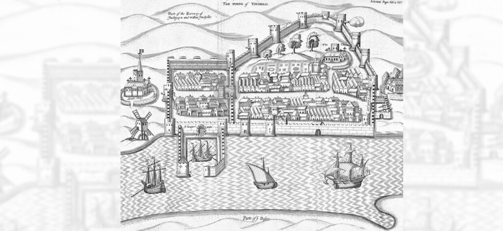
In the early 1300s, Youghal was a bustling town, with a market at the Main Street’s widest point and a busy port that welcomed ships from England, France, and Spain. However, the Black Death that hit the area between c. 1348-56 had a catastrophic effect on the town, causing its fortunes to decline. The 1300s saw several murage grants to revive the town’s growth, resulting in the addition of surviving towers along the west of the wall and the quayside town wall.

youghal-history-heritage-16th-century map of Youghal Co. Cork - Pacata Hibernia - circa 1587_

Oliver Cromwell

Oliver Cromwell’s historic sojourn in Youghal in 1641 marked a turning point in Ireland’s history. As the English administration battled civil unrest in the 1640s, Irish Catholic gentry sought to reclaim their political rights and religious freedom. Though their rebellion was partially successful, Youghal remained a strategic outpost under English control. In August 1649, Oliver Cromwell arrived in Youghal with his army of 10,000 soldiers to put down the rebellion. He made the old Priory of St. John’s on North Main Street his headquarters and wintered there. After his conquest, Cromwell departed Ireland from Youghal’s medieval Quay Gate in May 1651, sailing aboard the frigate “President” bound for Bristol. Today, Cromwell’s Arch stands as a symbol of his brief but significant stay in the town.

Boyle’s great grandson passed away without a male heir in 1753, and the lands passed through marriage to the Dukes of Devonshire. Bernard Scalé’s 1764 map of the town indicated that 273 residences in the town belonged to the Devonshire estate. Despite still being walled, the town was poorly maintained. In the late 1700s, the corporation invested in the improvement of the quays, reclaiming land along the riverside and allowing for the construction of large warehouses in this area of the town.

It was not until c.1215 that the town was formally established, after King John granted Thomas FitzAnthony custody of the region. With the patronage of FitzGerald, the town and port flourished, welcoming settlers from Bristol and southern England. Maurice FitzGerald established a Franciscan monastery on the southern side of the town in 1224, followed by his son Thomas’s establishment of a Dominican monastery on the northern side of the town in 1260. A charter granted by King Edward I in 1275 for the repair and expansion of the town wall suggests that the town was previously walled.

The College

The establishment of The College in 1464 by the eighth Earl of Desmond, Thomas FitzGerald, marked another phase of expansion. The continued support of the earls enabled the mendicants of the college to flourish throughout the middle ages and even survive for decades after the dissolution of the monasteries. Following the Desmond rebellion, Youghal was in dire need of repairs, and Walter Raleigh was granted a plantation to bring the town back under crown control in the 1580s. Raleigh sold the town to Richard Boyle in 1602. Richard Boyle is credited with the rapid and impressive expansion of Youghal in the 1600s, including the addition of alms-houses and schools and the acquisition of properties across the settlement, including the college. The town’s defenses and port facilities continued to be developed.

19th Century Growth

In the 19th century, Youghal continued to grow as a commercial town and became a significant center for pottery works. The opening of the train station in the 1860s presented Youghal with an opportunity to become one of the country’s most renowned Victorian tourist destinations. Today, Youghal has preserved the essence of its 18th and 19th-century streetscape, giving the town a strong heritage character and a unique charm. The town’s charm is further amplified by its rich stock of traditional shopfronts.

Table of Contents: Youghal History & Interactive Map

Interactive Map of Youghal History

LIGHTHOUSE

Erected circa 1850, this splendid structure boasts a magnificent domed lantern and an attached dwelling that served as the home of the lighthouse keeper.

Read our full page info on Youghal Lighthouse here.

BAYVIEW TERRACE

Originally christened as Louisville, these opulent Victorian seaside residences were constructed circa 1860 according to the designs of Dean and Woodward, two renowned architects of their time.

TRAIN STATION

Established in the early 1860s to connect Youghal with Cork City, the Cork and Youghal Railway (C&YR) Company formed part of the Youghal Midleton Greenway and is now a well-known destination for day trippers. Located some distance from the town at the strand, the station building displays exquisite decorative brick detailing.

GREEN PARK

Dating back to approximately 1900, this park features late Victorian elements, including an octagonal bandstand and a cast iron fountain.

THE CONVENT

This grandiose former convent is situated overlooking the southern entrance to the town and was constructed in several phases between 1834 and 1872. Today, it serves as a school.

SOUTH ABBEY/DEVONSHIRE ARMS HOTEL

This location once housed a Franciscan abbey founded in the year 1224. The abbey was later replaced by an elegant neo-classical style hotel, built by the Duke of Devonshire in 1826.

METHODIST CHURCH

This church was erected in 1880 and designed in a restrained style using locally sourced brick.

BARRACKS

Originally built around 1840 to accommodate six officers and 180 men, this barracks served as an infantry barracks in its early years. Today, it is part of Youghal Hospital.

TOWN WALLS

Among the most intact town walls in Ireland, the earliest sections of this structure date back to circa 1250 AD. For a beautiful and scenic short walk with lovely views, visitors can access the walls and College Garden from Raheen Road.

Read more here on our Youghal Town Walls page.

NORTH ABBEY

Founded in 1268, this Dominican Friary now only has a carved stone tracery window in the west gable wall remaining.

11 & 12 NORTH MAIN STREET

Originally built as a six-bay wide property circa 1780, this structure was divided into two shops during the 19th century. The building features exquisite render detailing.

MYRTLE GROVE

This building is a very rare example of a surviving 16th century urban house. Although the building is private, it can be viewed from the nearby Church grounds [13]. It is one of the earliest unfortified and still occupied houses in Ireland.

ST. MARYS COLLEGIATE CHURCH

Built circa 1220 in gothic style, this is one of the largest medieval parish churches in Ireland. A rare survival of 13th century oak roof timbers can be found here, and the church contains a colourful memorial in a sombre setting that features the 17th century effigy of Richard Boyle reclining over miniature carvings of his wives and children. It offers an engaging visitors experience.

Read our full page info on St. Mary’s Collegiate Church Youghal here.

THE COLLEGE

Originally established in 1464 as a college of choristers and lay brothers for Youghal and the surrounding area by the Earl of Desmond, the building was modified circa 1605 by Richard Boyle as a residence. Now serving as offices, the building underwent extensive rebuilding in 1782.

GARDENS

Behold the awe-inspiring 16th century terraced gardens, encompassed by towering walls that slope gracefully from the Town Walls down to Emmet Place. A rare and treasured gem, these gardens have managed to survive the test of time and bear witness to a bygone era. Discover the wonder of this public park that once held secrets of a walled garden dating back to ancient times.

FORMER BANK, EMMET PLACE

Cast your eyes upon the formidable former bank, constructed circa 1810 with a purposeful intent. Gaze in amazement at the meticulously crafted limestone plaque, adorning the facade of the town seal, depicting a towering ship and fortified medieval harbour. Such grandeur and magnificence will leave you in utter astonishment.

THE CONVENT

Delight in the sublime classical style building, that was once the parish priest’s house and a convent in times gone by. Let your imagination run wild as you ponder the origins of this magnificent structure, thought to have emerged from the 18th century, and imagine the lives of those who once walked its halls.

CARNEGIE LIBRARY EMMET PLACE

In the early 1900s, the Carnegie Library emerged from the ruins of a former Quaker Meeting House. Andrew Carnegie, an American industrial tycoon and philanthropist, played a significant role in establishing charitable educational institutions known as Carnegie Libraries. Take a moment to appreciate the historical significance of this building and the philanthropic efforts that made it possible.

ST. MARY’S ROMAN CATHOLIC CHURCH

Behold the majesty of this neo-Gothic masterpiece, constructed in 1794. Allow your eyes to wander across the Victorian encaustic tiled floors, the timber dado panelling, and the beautifully carved confessionals nestled under a three-sided gallery with organ. Let the grandeur of this holy place fill you with a sense of awe and wonder.

FIELD’S SHOP, 106 NORTH MAIN STREET

Transport yourself to a bygone era as you lay your eyes upon the iconic late 19th century shop. Admire the painstakingly hand-painted nameplate, situated on the reverse side of the glass and finished with gold leaf. Experience the wonder of a time when quality and craftsmanship were of utmost importance.

MERRICK’S SHOP, 83-80 MAIN STREET

Immerse yourself in the historic wonder of Merrick’s Shop, built circa 1900. Although the shop has been subdivided, the original façade remains intact, showcasing fine render detailing that is a testament to the incredible craftsmanship of days gone by. Allow yourself to be transported back in time to an era of elegance and sophistication.

CLOCKGATE

Let your senses be stimulated by the incredible landmark clock tower that straddles the main street. Built in 1777 on the site of the medieval Trinity Gate, this magnificent structure is open to the public and boasts three floors of fascinating exhibits, including a recreated merchant’s shop. Take a journey through time and experience the wonders of a bygone era.

Read more about this iconic structure on our dedicated page: Youghal Clock Gate Tower History.

TOWN HALL

Discover the hidden treasures of the Town Hall, built in 1779 on reclaimed ground. Once used as a courthouse and council chambers, this magnificent building continues to function as a public building. Allow yourself to be awed by the grandeur and historical significance of this iconic landmark.

WATERGATE

Behold the incredible gateway that straddles Watergate Street, marking the only point of access to the quays following the 15th century expansion of the town. Let your imagination run wild as you ponder the origins of this magnificent structure and the historical significance it holds.

COURTHOUSE

Constructed circa 1845, potentially based on a design by the esteemed architect William Caldbeck. The edifice comprises the posterior portion of the structure, which previously constituted a component of a pre-existing 17th/18th century customs house. During the years of the Great Famine from 1845-52, the facility was repurposed as a soup kitchen, providing sustenance to those in need.

PIER HEAD, MARKET DOCK

This sturdy stone quay was erected between the years of 1770 and 1777. Its formidable construction is a testament to the skilled craftsmanship of its builders and stands as a monument to the maritime industry that once flourished here.

MEAT SHAMBLES LANE

At one point, this narrow lane was the hub of a bustling meat market, or shambles. Its continued existence is a remnant of the medieval streetscape that once characterized the town of Youghal, serving as a poignant reminder of the area’s rich history and enduring traditions.

PRIORY

The medieval Priory of St. John. The only remaining structure is its gable wall, which faces the street. The wall boasts a pointed medieval door and a typical medieval ogee headed window that is made of Dundry stone. This piece of architectural wonder reminds us of the Benedictine house built in 1306.

PERMANENT TSB BANK

A distinct Edwardian-style bank that was built around 1910. Its unique feature is the robust render detailing that adorns its redbrick and render structure. The casement windows with irregular pane sizes complete the exquisite look of this building.

FORMER BANK OF IRELAND

Former Bank of Ireland, which was erected between 1840 and 1846 as a bank and manager’s house. It stands out with its limestone shopfront, which contrasts beautifully with the red brick façade.

SHOP, 31 MAIN STREET

At 31 North Main Street, we have a shopfront that dates back to the 19th century. It is a rare gem that still retains some of its original features, such as the wonderful tiled stall risers. This piece of architecture is a testament to the longevity and resilience of ancient buildings.

RED HOUSE

The Red House, built in 1703, is a shining example of the neo-Classical movement’s very beginnings. Its red brick construction would have been a dramatic statement on the streetscape. It is an architectural masterpiece that has stood the test of time.

ALMS HOUSES

The Alms Houses were built by Richard Boyle between 1613 and 1634 to provide shelter for six poor widows. These unusual buildings are a rare survival of late medieval houses and bear the Richard Boyle coat of arms. Remarkably, they still function as social housing, highlighting their importance in society.

TYNTE’S CASTLE

A late medieval urban tower house, is a rare example of an urban medieval tower house. It faces the main street and stands tall as a testament to the ingenuity and skill of ancient builders.

AIB BANK

Built between 1841 and 1846, has been altered since, but it still boasts a finely carved limestone shopfront. The intricate details and craftsmanship are a reminder of a time when beauty and elegance were the hallmarks of a building’s design.

136 MAIN STREET

We have a shopfront with wonderful carving evident in the detail of the brackets. The acanthus leaf, a decorative motif popular in ancient Greek architecture, is beautifully incorporated into the neo-Classical design of this building.

The Irish Historic Towns Atlas - Free Download

Youghal-History-Irish-Historic-Towns-Atlas-no.27-Free to download
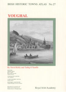
The Irish Historic Towns Atlas No. 27 – Youghal is now available for free download on the Royal Irish Academy’s website. This online version is perfect for those who have ancestral connections to County Cork’s town of Youghal, as it details the town’s growth and development over the centuries.

Authored by David Kelly and Tadhg O’Keefe, the Youghal IHTA was initially published in 2015. The atlas takes readers on a visual journey through the town’s history, starting from its beginnings as an Anglo-Norman borough and seaport, to its evolution as a market town and later, a seaside resort. The atlas contains a plethora of old maps and plans, which help to bring the story of Youghal to life.

The Youghal Irish Historic Towns Atlas also includes an explanatory essay and a historical gazetteer. The gazetteer features over 1,500 entries on various features of the townscape, such as streets, schools, town walls, tanneries, and more.

The free online version is available in a series of PDFs. These include the cover, general abbreviations, the 9-page essay, topographical information, a select bibliography, maps 1, 2, and 3, a growth map (map 21 in the original), and the legend sheet to map 2. To access the download page, simply click on the cover image.

It is important to note that certain historical maps and images that are available in the printed atlases are not included in the digital edition due to copyright restrictions.

The Youghal Irish Historic Towns Atlas is a valuable resource for anyone interested in the town’s history and development. The online version makes it more accessible and easier to read. We encourage you to download a copy today and learn more about this fascinating town.

Irish Heart, English Blood: The Making of Youghal - Author: Michael Twomey

Youghal, County Cork, has a long history which predates most other towns in Ireland. The area was settled by Vikings and subsequently fortified by the Normans in the 1100s. For centuries after, the town was a hub of trading activity and a vital port during the early stages of the English Empire’s expansion.

Irish Heart, English Blood looks at a period which saw all the elements and dynamics of this history come together in Youghal, from the 1569 and 1579 Munster rebellions to the witch-trial of Florence Newton in 1661, taking in en route, Walter Raleigh, Richard Boyle (the first millionaire colonialist), the Civil Wars, the ‘burnings’ by Lord Inchiquin and the invasion of Oliver Cromwell, revealing how its ordinary citizens survived extraordinary social, religious and political change.